 I went out on the bus to the castle on Tuesday, a day off, figuring that since hostel guests are always asking me about Loch Ness, I should finally see it for myself (that I can recall - I saw it in 2002 briefly).
Just because I discovered Google Maps the other week, I'm including a link to the map I made of my little trip, just to test it out. I always like to have a map to look at anyway when someone's talking about places, so perhaps you do as well (check out the terrain and satellite modes as well for a better view of the area). I've tried putting the HTML for the map into this post so that you can see it and click on it, but it has crashed this browser several times already.
It was a nice sunny day, as you can see from the photo, so it made for a good day to walk about. I strolled around the ruined castle at its excellent vantage point on a head of land that allows one to see both ways down the loch. The modern visitor centre is nicely hidden in the bank of the hill between the castle and the road, so it doesn't spoil one's attempts to imagine the castle as it was.
I later walked down the road to the village of Drumnadrochit, in the valley known as Glen Urquhart (the lands of which the castle protected and where all the cattle that the MacDonalds stole away back to the isles at one point were presumably pasturing). I spent a few hours wandering around in the woods and then into the farmland before catching the bus back to Inverness.

On Monday, I walked over the Kessock Bridge to North Kessock where I climbed up Ord Hill which is on Forestry Commission land. It was a hazy day so the light wasn't great for photos, but here's one of Inverness and surroundings as viewed from the north (the hill in the middle is Craig Phadraig that I climbed before).

The public rights of way around this country are neat. There's old paths and stairways between streets, paths through fields and woods and up hills. In Inverness, because it's hilly, there are stairs in the town centre to take you between streets, allowing you to save time on foot as compared to following the car routes. There's also paths between houses that are public as well. When I first lived anywhere "urban" it was in Kyleakin, and I wasn't used to all the idea of between garden paths (garden = yard). I saw the paths, but with my Canadian land mindset I figured I would be walking on to someone's lawn. It wasn't until I was walking through the village with a village resident who took some of those paths as shortcuts that I realized it was alright. Since most houses have gardens that are enclosed by low walls, hedges, or fences, with gates to enter them, if a path is between those walls and isn't gated then it's ok to walk down as far as I can tell.
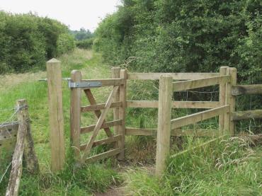
The paths in the "wild" so to speak, are often accessed via kissing gates, so that is how I generally figure out that it's a public path if there's no sign (since I don't tend to plan where I go well enough to have a map). I found one of the paths near Drumnadrochit because someone had kindly put up a big red sign that said "Public Footpath" and a stile (stairs, basically) over the roadside wall to what I would have assumed to be just a farm lane. I wouldn't have walked down it otherwise, and when I did I found some forest trails.
In Scotland, you basically have the right to access most land in the countryside for recreational purposes if you're reponsible according to the Scottish Outdoor Access Code. As it was first put to me, there's no such thing as tresspassing. So there's doesn't need to be a public footpath for you to go walking on land (whereas in England they have the public rights of way and then there's other land). I still stick to paths if I'm near houses, just because I'm uncomfortable walking through what might be the farm of someone I don't know. I tend to follow the rule I always used at home: if they cut the grass, I don't walk on it because it's a lawn.
No comments:
Post a Comment